| |
BHUVAN-NEWS-01Feb2014 |
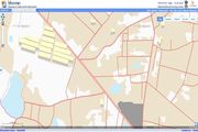
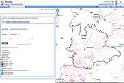
Bhuvan 2.5D
Bhuvan now brings 2.5 D City Models under its Visualization Services. Bhuvan 2-D viewer is updated with 2.5 D models of buildings, Infrastructure and Recreational areas for 136 towns.Visit
|
 |
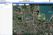
Crowd Sourcing(Mapper, Android POI App)
Bhuvan Mapper is a comprehensive application facilitating user to embed their local knowledge and create value added maps through association with Bhuvan. This portal allows you to tag places of interest of various categories along with description. Visit Bhuvan POI app(Android) - Download
|
 |
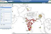
Pest Surveillance
Agriculture Pest/Disease Surveillance: Bhuvan Collaborative Portal, an initiative by NRSC/ISRO allows users to share, access and upload the pests and disease related information in a near real time basis. This portal serves as a visualization tool for the spatial representation of the pest and disease incidence reports.Visit
|
 |
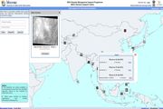
International Disaster
NRSC/ISRO is extending satellite data support under the following International Disaster programmes:
International Charter Space and Major Disasters to international Disaster events, Sentinel Asia Framework, United Nations Platform for Space-based Information for Disaster Management and Emergency Response (UN-SPIDER), United Nations Economic and Social Survey of Asia and the Pacific 2013 (UNESCAP) Visit
|
 |
Thematic Services
Thematic Services is enhanced with following datasets LULC 50K 2011-12 (12 states), LULC 10K - 62 districts, Erosion, Salt Affected and Water Logged Area, Water Bodies, Urban Sprawl.Visit
|
 |
Open Data Archive
Open Data Archive is extending its services through Global Coverage products GAC-NDVI and new products under Terrestrial Sciences: Water Fraction and under Ocean Sciences: TCHP, OHC, Wind Products. Latest 2011 LISS III Datasets are integrated. CartoDEM data enriched with new version V1.1 R1 data.Visit
|
 |
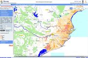
Disaster Services
Flood hazard Map for Odisha has been published which is prepared from information on inundated areas in Odisha during various floods from 2001-2013, Aggregated Flood Inundations have been intergraded (Flood, Tsunami and Cyclone).Visit
|
 |
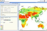
OSCAT Land Products
Oscat3D Visualization has been enabled with Opensoruce 3D, it has no dependency on any plug-in. Enabled time series visualization in viewer having Feb, May, Aug and Oct 2012 datasets.Visit
|
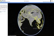 |
High Resolution Imagery(1m) of Cities
55 cities/towns 1m data from Cartosat-2 is made available for visualisation besides already available 2.5m data from Cartosat-1 data for major part of the countryVisit
|
 |
