Free Satellite Data Download
- Last edited 5 years ago by Bhuvan Admin
Contents
Free Satellite data download
The above URL facilitates selection, browse and free download of Satellite Data and Derived Products along with the metadata as per the NSDI 2.0 standards.The Satellite Data and Products derived from the Indian Remote Sensing (IRS) series of Satellite data have been segregated in to three classes based on Satellite, Theme and Project.
Satellite/Sensor
Under this category- Cartosat-1: DEM, IMS-1: Hyper spectral Imager, Resourcesat-1: AWiFS Ortho, Resourcesat -1: LISS III Ortho products are available for download. Also Oceansat-2: OCM, Oceansat-2: Scatterometer are also available through NRSC. Free Satellite data of 23 meters and coarser is made available to promote research and projects enabling universities, researchers and departments. Free downloadable Digital elevation models from Cartosat satellite for India which is useful for topographical studies. Ocean and climate related research requirements fulfilled by NICES products and diversity and frequency of these products and corresponding downloads
Theme/Products
Under this section various Geophysical products are disseminated under 3 Categories:
- Land Vegetation
- Land and Terrain
- Ocean Physical
Program/Projects
Through this section products are disseminated under 2 major categories, they are CatoDEM-1 arc sec and National Information System for Climate & Environment Studies (NICES).The Products under NICES are grouped under following sub categories:
- Atmospheric and Climate Sciences
- Ocean Sciences
- Terrestrial Sciences
Step by Step guide for free satellite and satellite derived data downloading
Step1
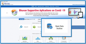
Click on "open data archive" and Login to Bhuvan
Step2
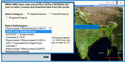
Select category- Satellite/ Sensor and Select sub category - Resourcesat-1LISS III (for more information read technical document attached)
Step3
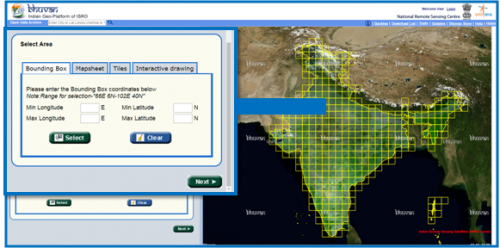
Select area- 1. By giving lat/lon 2. Mapsheet/Toposheet No 3. Tiles 4. Manual drawing
Step4
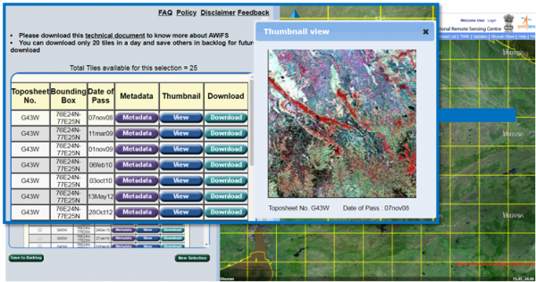
The list of total available datasets will be seen. you can select any of the scene from the list for downloading , Then click on Download, and unzip the folder and save it in any drive