Information for Developers
- Last edited 4 years ago by Bhuvan Admin
Contents
Bhuvan Framework
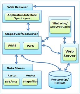
Bhuvan Geoportal has been developed using open source solutions.; Chosen Open source solutions are all well proven, having good community support, documentation and continuous support. All the Application developed can be scaled as there is no limitation of licenses, vendor dependencies.
Open Source Solutions used for the development of Bhuvan
| Software | Purpose | Licensing Scheme |
|---|---|---|
| OpenLayers API | Client-side scripting language | 2 Clause BSD license |
| Geoserver, Geowebcache | Serving Vector Data | GNU General Public License |
| UMN Mapserver, TileCache | Serving Raster data | MIT License |
| PHP – HyperTextPreprocessor | Server-side scripting language | |
| JASIG | Central Authentication Servicer | Own Open source license |
| PostgreSQL, PostGIS | RDMS | Liberal open source license |
| Apache and Tomcat Webserver | For serving the Web Pages | Apache License |
| JavaScript, JQuery, Vuejs | Client Side validations, navigation |
Existing Generic Framework code having the basic features for the development of application having visualization of Satellite, Base map data along with rich infrastructure data is made available. This framework general tool developed for Adding Layer (WMS, KML ...) Navigation, Swipe, Overlay etc. is provided for quick realization of applications.
APIs
Bhuvan Search Web API:
Bhuvan Search web API provides the users to connect Bhuvan database. Using Search API users can search by Place name and retrieve the latitude,longitude values of placename. We can search by place name/place-name, district or town name/place-name, dist or town name, state name/place-name , state name. The API supports partial text matching on place-name and exact match on town, state name Web API : http://bhuvan.nrsc.gov.in/search/placename
Application Development
• Web application developed using Bhuvan Template and other frameworks based on OGC services, Openlayers 2.0, HTML, JS and CSS with various other frameworks like JQuery/ Bootstrap. • Mobile application developed using Bhuvan POI Template/Bhuvan Panchayat Asset Mapping Template using Apache Cordova, JS, HTML, CSS and JQuery. • Data Discovery Application using Geonetwork Open source (GNOS), XML, XSL, Xpath, XQuery etc. • Mobile GIS applications like View assets Mobile using Mobile Friendly Leaflet, JQuery, JS, HTML, CSS. • Standalone Outreach Applications based on HTML5, JS, CSS for exhibitions related to space technologies/ museums /expos etc. • Decision Support Systems Dashboard for analyzing data from various applications using GeoServer, PostgreSQL, PostGIS etc. • Neighborhood mapping and GIS viewer for creating data and visualizing non-spatial data into spatial form.
