You are viewing an old version of this page. Return to the latest version.
Version of 16:46, 6 January 2020 by Bhuvan Admin
Difference between revisions of "Thematic Data"
Bhuvan Admin (talk | contribs) (Created page with " Back {| cellpadding=20 cellspacing=0 |- ! width="100%" | Thematic Maps |- | style="padding: 0 1.5em; text-align: justify;" | Currently the URL http...") |
Bhuvan Admin (talk | contribs) |
||
| (6 intermediate revisions by the same user not shown) | |||
| Line 1: | Line 1: | ||
[[Information_for_Users|Back]] | [[Information_for_Users|Back]] | ||
| − | + | ==Thematic Maps== | |
| − | + | <div style="text-align:justify">Currently the URL http://bhuvan.nrsc.gov.in/gis/thematic/index.php provides thematic services on Bhuvan. Various thematic layers for land use land cover data, urban land use, waste land, glacial lake water bodies, geomorphology, lineament, flood hazard, flood annual layers, erosion, salt effected and water logging, water bodies and urban sprawl are available for visualization on this link. All these layers have the provision to be accessed as WMS service through various clients like OpenLayers, QGIS, ArcGIS etc. These services can also be linked to website in internet or local area network. These thematic layers are available only on Bhuvan for India and this makes Bhuvan unique. API's are being developed for these layers for easy usage on other websites.List of available thematic maps- | |
| − | |||
| − | |||
| − | |||
[https://bhuvan-app1.nrsc.gov.in/thematic/thematic/index.php Thematic data URL] | [https://bhuvan-app1.nrsc.gov.in/thematic/thematic/index.php Thematic data URL] | ||
| − | |||
*Land Use Land Cover (LULC) | *Land Use Land Cover (LULC) | ||
| Line 20: | Line 16: | ||
*Flood Annual Layers | *Flood Annual Layers | ||
*Glacial Lakes and Water bodies (Indian Himalayan region) | *Glacial Lakes and Water bodies (Indian Himalayan region) | ||
| − | + | </div> | |
| − | </ | + | |
| − | + | ==WMS Services== | |
| − | + | <div style="text-align:justify"> Bhuvan allows users to add Web Map Services directly on to the portal. . Bhuvan web map services are OGC complaint towards Interoperability. Add Web Map Service (WMS) option enables users to connect and visualize external web map service along with services/data available in Bhuvan by providing layer name and layer URL. Bhuvan also has WMS Manager which facilitates to connect with external web map service providers to bring all web map services and visualization, users can also submit the URL for other users to access the services. These tools facilitate users to bring diverse data which is available as web map service on internet and visualize along with rich Bhuvan satellite and thematic data. | |
| − | + | </div> | |
| − | + | ||
| − | |||
| − | |||
| − | |||
| − | </ | ||
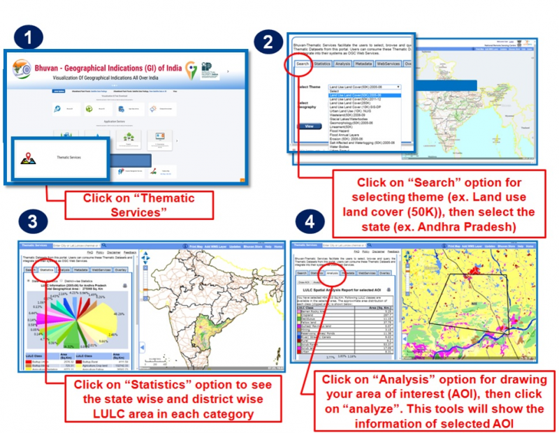
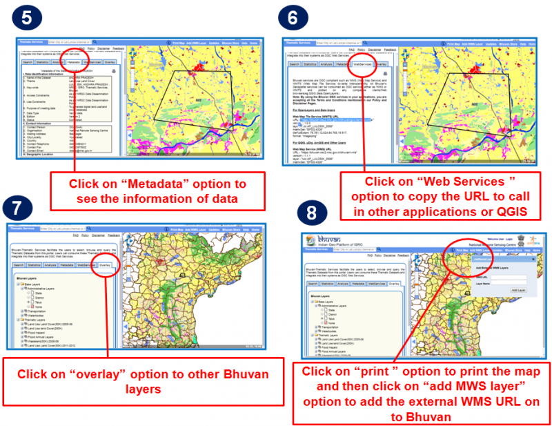
== Steo by Step guide for Thematic Data == | == Steo by Step guide for Thematic Data == | ||
| − | [[File: | + | [[File:thematic_112.png|link=|800px]] |
[[File:thematic_2.png|link=|800px]] | [[File:thematic_2.png|link=|800px]] | ||
Latest revision as of 06:30, 19 March 2021
Thematic Maps
Currently the URL http://bhuvan.nrsc.gov.in/gis/thematic/index.php provides thematic services on Bhuvan. Various thematic layers for land use land cover data, urban land use, waste land, glacial lake water bodies, geomorphology, lineament, flood hazard, flood annual layers, erosion, salt effected and water logging, water bodies and urban sprawl are available for visualization on this link. All these layers have the provision to be accessed as WMS service through various clients like OpenLayers, QGIS, ArcGIS etc. These services can also be linked to website in internet or local area network. These thematic layers are available only on Bhuvan for India and this makes Bhuvan unique. API's are being developed for these layers for easy usage on other websites.List of available thematic maps-
- Land Use Land Cover (LULC)
- Wasteland
- Geomorphology Lineament
- Urban Land Use
- Urban Sprawl
- Erosion
- Water Bodies
- Salt Affected & Water Logged Area
- Flood Hazard
- Flood Annual Layers
- Glacial Lakes and Water bodies (Indian Himalayan region)
WMS Services
Bhuvan allows users to add Web Map Services directly on to the portal. . Bhuvan web map services are OGC complaint towards Interoperability. Add Web Map Service (WMS) option enables users to connect and visualize external web map service along with services/data available in Bhuvan by providing layer name and layer URL. Bhuvan also has WMS Manager which facilitates to connect with external web map service providers to bring all web map services and visualization, users can also submit the URL for other users to access the services. These tools facilitate users to bring diverse data which is available as web map service on internet and visualize along with rich Bhuvan satellite and thematic data.
Steo by Step guide for Thematic Data