Difference between revisions of "Bhuvan 3D"
Bhuvan Admin (talk | contribs) (Created page with "Back == Bhuvan 3D == [https://bhuvan-app1.nrsc.gov.in/globe/3d.php# Bhuvan 3D URL] *It shows three dimensional representation of objects on Bhuvan...") |
Bhuvan Admin (talk | contribs) |
||
| Line 3: | Line 3: | ||
== Bhuvan 3D == | == Bhuvan 3D == | ||
[https://bhuvan-app1.nrsc.gov.in/globe/3d.php# Bhuvan 3D URL] | [https://bhuvan-app1.nrsc.gov.in/globe/3d.php# Bhuvan 3D URL] | ||
| + | <div style="text-align:justify"> | ||
*It shows three dimensional representation of objects on Bhuvan platform. This enables Multi sensor, Multi platform and Multi temporal data display along with the height information. | *It shows three dimensional representation of objects on Bhuvan platform. This enables Multi sensor, Multi platform and Multi temporal data display along with the height information. | ||
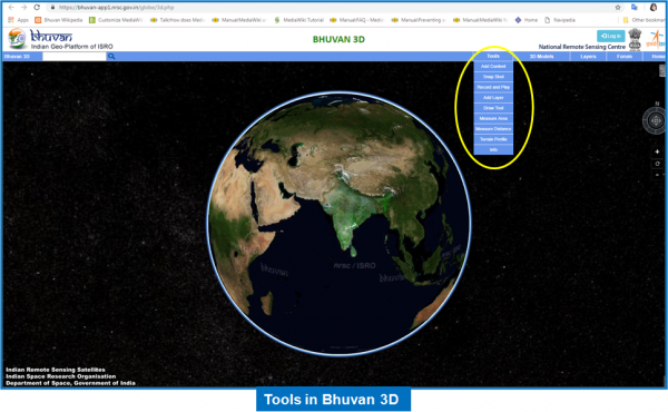
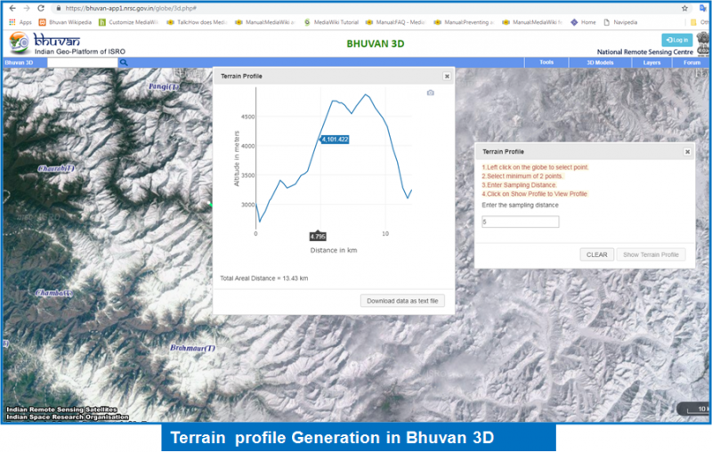
* Users can find terrain profile along with other features like- capture screenshot, info, add layer, draw layer, measure area etc. | * Users can find terrain profile along with other features like- capture screenshot, info, add layer, draw layer, measure area etc. | ||
*3D globe displays satellite imagery and it can be changed to view the globe as maps instead of satellite imagery. | *3D globe displays satellite imagery and it can be changed to view the globe as maps instead of satellite imagery. | ||
| − | * | + | *It provides facility to overlay Administrative boundaries, Road and Rail, Panchayat boundaries, Sub Basin, Basin and River layers. |
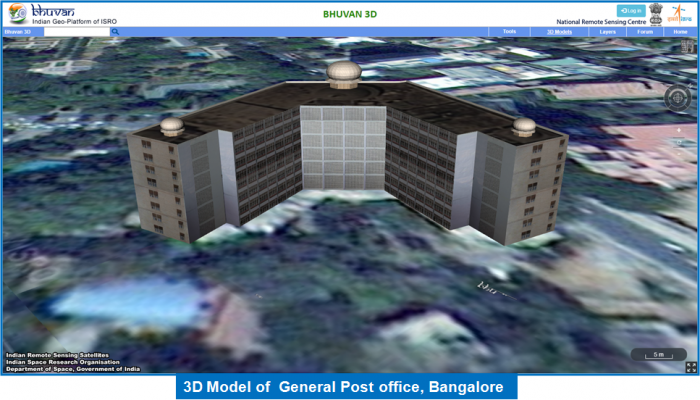
*It provides visualization of 3D models for six Cities. Bhuvan facilitates to obtain the 3D models from the community. If they can share the 3D models in required format with us, after validation it will be hosted on to the public domain. | *It provides visualization of 3D models for six Cities. Bhuvan facilitates to obtain the 3D models from the community. If they can share the 3D models in required format with us, after validation it will be hosted on to the public domain. | ||
| − | + | <div style="text-align:justify"> | |
[[File:tools_3d.png|link=|600px]] | [[File:tools_3d.png|link=|600px]] | ||
[[File:3d_model.png|link=|700px]] | [[File:3d_model.png|link=|700px]] | ||
[[File:terrain_profile.png|link=|800px]] | [[File:terrain_profile.png|link=|800px]] | ||
Latest revision as of 09:14, 10 March 2021
Bhuvan 3D
- It shows three dimensional representation of objects on Bhuvan platform. This enables Multi sensor, Multi platform and Multi temporal data display along with the height information.
- Users can find terrain profile along with other features like- capture screenshot, info, add layer, draw layer, measure area etc.
- 3D globe displays satellite imagery and it can be changed to view the globe as maps instead of satellite imagery.
- It provides facility to overlay Administrative boundaries, Road and Rail, Panchayat boundaries, Sub Basin, Basin and River layers.
- It provides visualization of 3D models for six Cities. Bhuvan facilitates to obtain the 3D models from the community. If they can share the 3D models in required format with us, after validation it will be hosted on to the public domain.