Bhuvan 2D
- Last edited 4 years ago by Bhuvan Admin
Contents
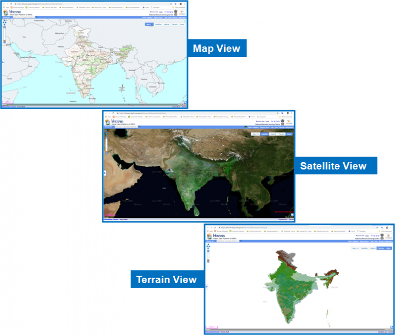
Bhuvan 2D visualization interface is designed to provide the following
- Map view: The map view provides administrative(State, District, Tehsil, Village) and hydrologic base ( Basin, Sub-basin, Watershed) for the entire country.
- Satellite image view: The satellite view provides I m, 2.5 m, 23m, and 56 m resolution satellite data for the entire country
- Hybrid: It provides the satellite as well as map view
- Terrain view: It provides terrain view (with altitude)
Geoprocessing tools
Tool Button: The ‘Tool Button’ on the top right hand corner of the page, when clicked, expands to display 7 different tools. These seven tools perform the following functions:
- Zoom-In: This tool helps the users to zoom-in to a particular location from their current location on the 2D map.
- Zoom-Out: This tool helps the users to zoom-out to a particular location from their current location on the 2D map.
- Full- Extent: The Full-Extent tool helps to zoom out of the current location of the user to the maximum extent of the map.
- Fixed Zoom-In: This tool helps the users to zoom-in to a particular location in a fixed manner, from their current location on the 2D map. Users can zoom into a location at a fixed level of zoom, at a time.
- Fixed Zoom-Out: This tool helps the users to zoom-out to a particular location in a fixed manner, from their current location on the 2D map. Users can zoom out from a location, at a fixed level of zoom, at a time.
- Go Back to Previous Extent: This tool takes the users to the immediate previous location accessed by them on the Bhuvan 2D map. With the help of this button, users can go back to all the pages they had accessed, in the backward order.
- Go to the Next Extent: This tool takes the users to the pages accessed by them on the Bhuvan 2D Map, in a forward manner.
- Overview Map: The Overview Map feature displays an additional view of the earth, with a position indicator that corresponds to the user’s current view inside the 2D map. This shows a miniature overview of the user’s current location on the map, and also reflects the change on the overview map as the user navigates on the 2D map.
- Create layer and add layer: This tool allows to create shapefile online and option to add created shapefile or any other shapefile. How to create a shapefile is explained below-
- Step1 Click on "Bhuvan 2D"
- Step2 Click on "Tools" option at the top right side of page, then select "Draw Tool". Use the Draw tool to digitize your area of interest and creating shapefile. Tool options - Point - for point features (college, building etc.)Line- for linear features (road, river, rail etc.) Polygon- for area features (lake, pond, fields)
- Step3 After creating shapefile click on download option
- Step4 Select all four files (dbf, pfj, shp, shx) from downloaded zip folder and zip them again
- Step5 Click on add layer, select shapefile and then upload
- Proximity:This tool shows all near by location points with various information such as-Hospitals, schools, shopping mall, hotels etc. Steps are given below to explore 'Proximity Analysis' with any of the given category
- Step1 Click on "Bhuvan 2D"
- Step2 Click on "Tools" option at the top right side of page, then select "Proximity".
- Step3 Enter any location- ex. Hyderabad
- Step4 Then select category -Health, shopping, hotels etc (as per your interest)
- Step5 Give buffer value - (ex-5 or 10 km), it means we are selecting the area 10 kilometer from Hyderabad city center to see the health, shopping location points
- WMS Manager:This tool allows to consume web map services for importing the layer or exporting the layer.Steps for accessing Bhuvan WMS services in external Software -QGIS is given below-
- Step1 Click on "Thematic Services"
- Step2 Select Land use land cover(250K)
- Step3 Select Year- 2017-18
- Step4 Click on "view"
- Step5 Now select 'Web services "Option
- Step6 Copy the url "https://bhuvan-ras2.nrsc.gov.in/cgi-bin/LULC250K.exe"
- Step7 Open QGIS and navigate to the toolbar at the top of the window. Select 'Add WMS Layer' from the toolbar options
- Step8 This opens a new window titled ‘Add Layer(s) the select "connect"
- Step9 Give the name of layer and paste the copied url
- Step10 Click on "Ok"
- Add Content/ Through Mobile app- Bhuvan POI:• How to add Add Points with photographs through Add Content Option in Bhuvan2D is explained -
- Step1 Click on "Bhuvan 2D"
- Step2 Click on "Tools" option at the top right side of page, then select "Add photos/POI ". add point by filling the asked information -
- Step3 Add content through mobile- Download the apk and install the downloaded apk into your mobile
- Step4 Send the valid POI of important locations of your place
- Historical/time series dataset of any given area of interest: how to see historical data sets is explained below-
- Step1 Click on "Bhuvan 2D"
- Step2 Switch to satellite view from map view
- Step3 Search your city/any location for finding available data sets
- Step4 Click on icon near to tools to see available data sets
- Step5 Tool will give the list of all available datasets for that area
Special display option
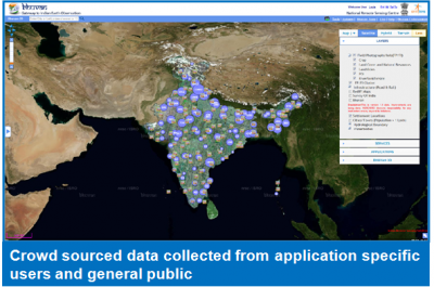
Bhuvan 2D provides an option to view the crowd sourced data, collected in various applications by different users and public. It has facility to visualize such field data with respect to various categories (Crop, Point of Interest, Landslides and etc). In addition, it has also facility to visualize Filed -Photographs/Field info clusters
Visualization of ISRO Automatic Weather Stations
It facilitates finding weather information of ISRO Automatic Weather Stations with current and archived data/information in a graphic view and use of tabular weather data of user choice. It facilitates to find weather information of any place in India using nearest AWS stations information. It also has visualization of Ocean Services like Potential Fishing Zones, Chlorophyl and Sea Surface Temperature with other data on Ocean, such as, Agro Floats, Moored Buoys, Waverider Buoy etc.

